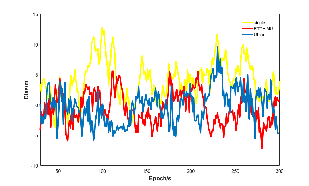
Under ideal conditions, standalone Global Navigation Satellite System (GNSS) technology can deliver positioning results with sufficiently high precision. Nevertheless, it suffers from numerous limitations under special operating conditions and application scenarios. For instance, in complex urban environments, multipath components in observations increase drastically. In more extreme cases, observation dropout may occur, and the number of observable satellites can drop below the minimum required for positioning computation, rendering GNSS incapable of providing effective navigation independently. Additionally, GNSS systems typically output positioning solutions at a frequency ranging from 1 Hz to 20 Hz, failing to meet the demand for higher-rate positioning in highly dynamic scenarios—this constitutes one of the major drawbacks of GNSS positioning. To address the aforementioned limitations, multi-sensor integrated navigation has emerged as a prevalent solution and represents the prevailing development trend for navigation in unmanned systems.
The advent of integrated navigation is an inevitable outcome driven by advances across multiple technological domains, which can be attributed to three primary factors. First, the cost of sensors has declined continuously. Inertial Measurement Units (IMUs) and high-definition cameras are ubiquitous in modern smartphones, while other sensors such as magnetometers and barometers have also become more affordable following technological maturation, facilitating easy access to multi-sensor measurements. Second, computing performance has been greatly enhanced. Data fusion processing for multiple sensors entails high computational complexity, which imposes stricter requirements on system processing capacity. Third, a wealth of auxiliary data has become available, including 3D maps, street view imagery and signal databases, laying a solid data foundation for vision-aided navigation technologies.


Beyond satellite navigation, a wide array of alternative navigation technologies exists, vision navigation being a representative example. However, no single navigation technology offers fully reliable performance, as each exhibits inherent drawbacks under certain operational conditions. For GNSS and other radio-based navigation systems, signal interference and obstruction constitute the primary factors degrading positioning accuracy in complex environments. Dead reckoning relying on inertial sensors suffers from unbounded error accumulation over time. Vision navigation, meanwhile, yields unsatisfactory performance in scenarios with sparse or indistinct visual features.
Given the above technological constraints and developmental context, the necessity of integrated navigation becomes prominent. From the perspective of availability, at least one navigation modality can always sustain fundamental navigation functionality across diverse environments. In terms of positioning accuracy, supplementary navigation measurements enable higher precision and more accurate calibration of sensor errors. Furthermore, redundant navigation measurements facilitate easier detection of faults, theoretically improving the integrity monitoring capability of the navigation system.
That said, integrated navigation introduces a host of technical challenges. On one hand, fusing disparate navigation technologies involves cross-disciplinary expertise, raising the costs and complexity of research and development. On the other hand, multiple navigation sensors can be combined in numerous configurations with varying levels of integration depth. Integrating a new sensor into an existing integrated navigation system often requires full hardware or software redesign of the original framework; developing methods to avoid extensive redesign while preserving original navigation performance remains a critical challenge. Finally, from an integrity monitoring standpoint, the fusion of heterogeneous observations complicates fault root-cause analysis, requiring modeling and estimation of diverse navigation failure modes. Accordingly, integrity monitoring in integrated navigation remains an area ripe for further research.
The Inertial Navigation System (INS) is an autonomous navigation system built upon Newtonian mechanics. It employs an IMU to measure kinematic quantities including acceleration and angular rate, and solves for real-time position, velocity and attitude by integrating kinematic differential equations. A key characteristic of INS is its ability to generate high-precision, high-rate outputs over short time intervals, yet its accuracy degrades progressively with elapsed time. By contrast, GNSS delivers long-term stable performance with nearly time-invariant error characteristics. GNSS and INS thus exhibit complementary strengths: INS supplements GNSS to maintain continuous navigation trajectories and provides temporary navigation capability during satellite signal outages, while the long-term stability of GNSS positioning restrains INS error drift. Fusing GNSS and INS can largely offset their respective shortcomings, yielding navigation solutions with superior precision and robustness.
Extensive research has been conducted on GNSS/INS integrated navigation. Based on the degree of mutual interaction between GNSS and INS measurement information, integration architectures are generally categorized into loosely coupled, tightly coupled and deeply coupled schemes. In loose coupling, processed GNSS positioning solutions are fused with inertial navigation data to generate the final navigation output. Tight coupling feeds raw GNSS observations alongside inertial measurements into a central filter for joint processing, featuring deeper integration. Deep coupling eliminates the separation of GNSS and INS as independent subsystems through hardware-level integration: GNSS observations are used to estimate INS errors, while inertial measurements assist the signal tracking loops of GNSS receivers. Loose and tight coupling architectures are widely adopted in unmanned systems, whereas deep coupling requires customized hardware design and manufacturing and is therefore less common. Though tighter coupling incurs higher implementation complexity and computational latency, it delivers superior positioning accuracy under weak or lost GNSS signals, making it widely deployed in complex environments with poor satellite reception.
Antonio carried out comprehensive experimental analysis on the positioning performance of GPS/GLONASS/INS integrated navigation, comparing different coupling and integration architectures under various environmental conditions. His research concluded that both loose and tight coupling deliver satisfactory positioning accuracy in nominal environments or during brief signal outages, outperforming standalone satellite navigation. In highly complex scenarios (where satellite navigation solutions are available for 80% of the duration, with maximum signal outage reaching 45 seconds), loose coupling produces substantial positioning errors with a root-mean-square (RMS) error of approximately 30 meters and peak errors up to hundreds of meters during extended outages. Tight coupling achieves drastically improved performance under the same conditions, with an RMS error of around 5 meters and peak errors capped at 100 meters, demonstrating the evident positioning superiority of tight coupling in complex environments.
Nevertheless, the above research reveals that GNSS/INS integration alone can only boost accuracy under good satellite visibility or maintain navigation stability during short signal interruptions. For prolonged GNSS outages (lasting tens of seconds or longer), significant positioning errors emerge regardless of the coupling scheme adopted, necessitating auxiliary technologies to mitigate such degradation. Consequently, multi-sensor integration incorporating radar, vision sensors and other equipment further augments the navigation system, with the ultimate goal of sustaining viable navigation performance amid long-duration weak or absent satellite signals.
Dae et al. investigated GNSS/INS/Vision integrated navigation for scenarios with fewer than four visible satellites over extended periods. Their proposed model leverages GNSS ranging measurements to aid vision-based navigation integration. The curves tracking positioning error against time under varying satellite visibility show that the model maintains stable navigation performance for several minutes with only three GPS satellites in view. As the number of visible satellites declines further, positioning errors transition from oscillatory fluctuations (two GPS satellites) to monotonic accumulation (one or zero GPS satellites). While this approach improves system stability when satellite navigation fails to compute valid solutions, large errors still persist under extremely harsh conditions.

Moreover, multi-sensor integrated navigation requires adaptive switching between optimal navigation modes as environmental conditions change. In additional research by Dae, a GNSS/INS/Vision integrated navigation framework was developed, with quantitative performance metrics evaluated across various scenarios to support dynamic mode selection (INS-only, Vision/INS, GNSS/INS, or full GNSS/Vision/INS), enabling adaptive operation across diverse environments.
It is evident that multi-technology fusion represents the core development trend for unmanned system navigation. Although GNSS delivers exceptional navigation performance under ideal conditions, tapping into the complementary potential of diverse sensors is indispensable to tackle complex, non-ideal operational environments.

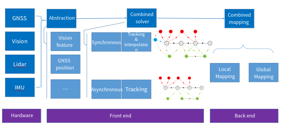
The primary advantage of multi-sensor integration lies in its flexibility to satisfy navigation requirements across varied scenarios, which underscores the critical importance of environment detection and recognition. Identifying distinct operating environments (open outdoor spaces, dense urban canyons, indoor premises, etc.) and motion profiles (ground mobility, aerial flight, etc.) to select optimal navigation modalities remains a prominent challenge in integrated navigation research. Additionally, verifying the integrity of positioning outputs generated by integrated navigation systems poses considerable difficulty. Integrity assessment demands estimating the occurrence probability of diverse navigation failure modes, along with the statistical characteristics of observations under each failure condition, as well as the temporal and cross-correlation properties of all error sources. The figure illustrates a suite of potential navigation sensors used in vehicular navigation. When a navigation system draws measurements from multiple heterogeneous sources, system design becomes highly intricate: designers must exploit the unique strengths of each navigation technology for different environments while conducting real-time integrity checks on all observations to avoid erroneous navigation outputs, and acquiring reliable prior statistical parameters for such modeling can prove arduous. Furthermore, excessive system coupling often mandates full framework redesign upon introducing new sensors, compounding the complexity of system development.